

Ancient astronomers noticed that although the planets moved irregularly, they always appeared in the same narrow band of the sky. Today, we know that this narrow, 9 °-wide section of the sky represents the plane of our Solar System. (All of the planetary orbits in our Solar System lie in roughly the same plane).
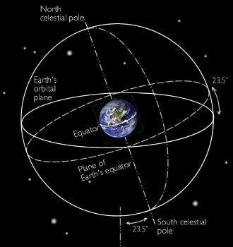
Because the Earth is tilted on its axis by 23.5°, the plane of the Earth's orbit (and Solar System) is thus tilted with respect to the horizon by 23.5°. (See the illustration).
Ancient observers named the 9°-wide region of the night sky where the planets appear the “Zodiac.”
Measurement
How did astronomers chart the movements of the stars without modern equipment?
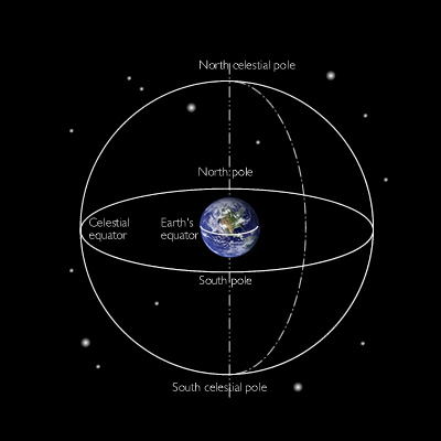
The North Star acts as reference point because all of the other stars pivot around it (at least in the Northern Hemisphere). Observers could measure the vertical angle (colatitude) between the North Star and other stars.
Observers also imagined a “celestial equator” at the great circle on the celestial sphere 90° from the pole star. This great circle represents the equator of the Earth projected out into space.
To measure longitude, observers made note of the constellations that straddled the Zodiac, the 9° band of the sky where the wandering stars appeared. The constellations or "fixed stars" are so far away that they do not appear to move with respect to each other, at least as observed with the instruments of Kepler's day. Ancient astronomers created a functional longitudinal coordinate system based on twelve constellations that straddle the Zodiac.
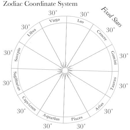
Ancient astronomers divided up the 360° circle of longitude on the Zodiac into 12 sections of 30° each, and named each 30° section for the most prominent constellation in it. Two bright stars, Antares and Aldebaran, lying 180° opposite from each other in the center of their respective constellations anchored the system and served as points of reference.
During the time of astronomer Johannes Kepler, longitudinal stellar measurements were reckoned as follows: “22° 11 minutes 6 seconds Libra,” indicating the angular distance a star was found beyond a particular constellation.
All the major Eurasian civilizations of the ancient world (India, China and Mesopotamia) shared the Zodiac coordinate system, which endured for centuries.